Distance: 11 miles

Start/finish: High Street/Buckwood Road Markyate, on street parking; Tring station pay car park.

Map: Ordnance Survey Explorer map 182 and 181.

Public transport: To get to Markyate: Buses: 34 from Markyate High Street via Redbourne to St Albans City station. Service runs hourly from Monday to Saturday.  No service on Sundays and Banks Holidays.  No bus link to Tring railway station.  Trains from Tring stop at Berkhamsted, Hemel Hempstead, Apsley and King’s Langley.  Aldbury has local services.

Pubs/refreshments:

No pubs en route until Aldbury at the end of the day. There are refreshments available at Bridgewater Monument on the Ashridge Estate. 

Route description: With apologies to William Wordsworth you can “wander lonely” for hours on end on this delightfully rural leg. There is incontrovertible proof that a lot of Hertfordshire countryside is dedicated to agriculture as obvious footpaths lead you through a series of arable fields. The highlight is unequivocally, the impressive 4,000 acre Ashridge estate and at the foot of its escarpment the scenic village of Aldbury. The only pubs you will pass on this stretch are both in Aldbury – though you haven’t far to go at this point before journey’s end. On a good day this is a blissful walk.  Simple. Without any distractions. Worthy of your time.

It’s virtually impossible to get lost on this stretch unless, like me, you are so distracted by the scenery you miss the signposting and end up on the edge of someone’s allotment. Nice marrows though. Once again the official guide is faultless in directing you the near 11 miles to Tring or the ten miles to Aldbury. I must confess the hedonistic delights of Aldbury, with its two pubs, proved too much of a lure and I called it a day at The Greyhound, a delightful place opposite the village pond. But let’s start in Markyate.

From the High Street turn into Buckwood Road, stay on the left and walk past all the houses to a footpath signposted to Roe End Lane where you will end up if you follow the path as it heads uphill – ignoring the first path on the right – then bends right around the edge of the field, goes through a gate in the hedge and then, unerringly in tune with the reliable roundel, continues along the track to the road.  In the true spirit of the Hertfordshire Way you will be heading south-west all day except when you’re directed east, west, north-west and south-east.  But fortunately not north unless you’ve got the map upside down. From Markyate to Jockey End you’re unlikely to meet few, if any, fellow ramblers. If you walk mid-week you won’t meet anybody. Don’t take it personally.,

The first heavily cultivated miles after leaving Markyate.

At Roe End Lane turn right and pass Roe End Farm and Holly Bush Home Lodge. Turn left and, with Gravelpits Wood on your right, follow the track to Beech Wood Farm, turn left at the crossroads and walk to Beechwood School. On this stretch I was overcome with feelings of envy for the occupants of the houses you will pass on your right. They enjoy uninterrupted views north east over rolling acres of cereal crops, pasture and woodland. Vibrantly colourful on the summer’s day I walked this leg. Not another property in sight and Markyate tucked in the folds of the land. A peaceful spot to sit and admire the views  –   and wonder whether the homeowners are willing to sell.

It was at this point that I was forced to confront a puzzling question. What is the difference between wheat, barley, corn, oats, maize and rye – apart from the fact they are grasses?  I have lived surrounded by farmland for 30 years but have never been able to identify one from the other.  Confronted by breeze wafted acres of what I – probably incorrectly – decided was barley I moved on none the wiser. And thought of Weetabix.  

Soon you’ll reach the supposedly haunted Beechwood Park School (below), a co-educational independent day and flexi boarding school opened in 1964 in the near derelict former family home of the aristocratic Sebright family.  www.beechwoodpark.com. The mansion and its Capability Brown designed grounds were used for the 1964 film The Dirty Dozen and were the subject of the 1967 song “Beechwood Park” recorded by St Albans band The Zombies whose writer and guitarist Chris White lived in Markyate.

Walk past the mansion and the playing field on your right until you reach a Hertfordshire Way sign at the left hand side of the road. It directs you into a copse and alongside the sports pitches to a kissing gate overlooking a large field (below left). Unless since changed the roundel here is pointing slightly askew to the right. The route lies directly ahead to a road. One tip. Some of the Hertfordshire Way roundels are nailed to the top of wooden posts at stiles and kissing gates and can be overlooked unless you are vigilant. But normally it is evident where they are and where they are directing you too.

On reaching the road turn immediately right and right again – virtually a U turn – and walk up Dean Lane (above right) alongside Deans Wood. It gets very muddy. After ten minutes a sign will point you towards the wonderfully named hamlet of Jockey End. Turn left along Gaddesden Row for a short way until that distinctive sign directs you to a path opposite which passes allotments and then follows a path across fields past a large house called The Hoo rubbing shoulders with woods on your right before entering the trees and then dropping down through fields to Dagnall Road (A4146).  Cross and an obvious gate opens into a field where a tell-tale wooden bridge straddles the River Gade.  https://en.wikipedia.org/wiki/River_Gade 

The Gade, like the Ver (see leg 5 for information about such rivers, their biodiversity and geology) is a rare chalk stream that runs almost entirely through Hertfordshire from a spring in the Chiltern Hills at Dagnall in Buckinghamshire to its confluence with the Colne at Rickmansworth.  Like the Ver its influence on milling along its course was once significant, the river being used to power water mills at Water End, Cassiobury and Two Waters and paper mills at Apsley and Croxley. Also, like the Ver, it supported the farming of watercress until its volume dropped when water was diverted from the river in 1947 to supply the growing new town of Hemel Hempstead. The water in the Gade, cooled by its journey through the porous chalk layers, remains at a constant temperature of 56 degrees Fahrenheit irrespective of hot summers or freezing winters.  

But the river is a shadow of its former self and, due to over-zealous extraction, was nothing more than a sluggish apathetic dribble when I crossed the almost unnecessary bridge. It is now unnavigable along its entire length.     

The River Gade in winter
Looking across the Gade valley to Great Gaddesden

After the bridge head towards Great Gaddesden on a marked route and look out for Church Meadows and a row of garages at the end of the cul-de-sac. A signpost will direct you right.  Around this point I disturbed two cheesed-off looking alpacas in an enclosure and a man dressed in Buddhist robes who was tending them. I’d wager he is the only Buddhist alpaca herder in Hertfordshire.  It’s amazing what you can suddenly discover on these walks. When you reach the road turn right past the Amaravati Buddhist monastery and keep walking for half a mile. In a large field to your left you’ll see an isolated cluster of trees. That’s where you’ll be heading.  At a sign on the left, and confronted with an obvious path, head to the right of those trees and drop down into a small valley. Turn right in the dip and look for a gate in a fence around 45 degrees to your left.  When you emerge from the field cross straight into Cromer Close opposite and find a footpath between tall hedges.  The sign here had disappeared into the foliage when I arrived but it directs you to a small playground where there is a welcome picnic table.  Have a short break here before embarking on what is effectively the last stretch. And TFHW have contrived to leave the best until last. Identify the gap in the perimeter trees and leave the play area to head left on a path through some woods.  When a track appears below to the right follow it on an obvious route into a pleasant valley and then left up the hill to a car park.  You are now on the stunning Ashridge estate, a place I confess I had never heard of and certainly never visited.   My loss I think.

The 5,000 acre National Trust owned estate is a showcase of woodlands, commons and chalk down land, criss-crossed by outstanding waymarked paths, occupied by herds of deer, a rich variety of wildlife and striking bluebell woods.   The National Trust has been responsible for the estate, bar Ashridge House, since 1921 and the extensive grounds are now designated as a Biological Site of Special Scientific Interest.  www.nationaltrust.org.uk/ashridge  Francis Egerton, the 3rd Earl of Bridgewater, started developing the estate as a family residence in 1800, three years before his death. The current Grade I listed neo-Gothic Ashridge House (below) was built between 1808 -14 and is regarded as one of the country’s finest examples of early Gothic Revival architecture.  In 1959 it became a management college.

It’s intriguing to know, as you continue to embrace the beautiful Hertfordshire countryside on a soul-lifting summer’s day, that there are people sitting in lecture rooms being coached in corporate gobbledegook.  “We need a more blue-sky approach to facilitating reciprocal options.” “We need to cascade strategies about our interactive third-generation alignment.”  How about:  “We’re going forward with our plans to implement knowledge-based asset streamlining.” Just the kind of tortuous drivel that saps the spirit. I think some of the senior managers at the BBC, where I worked for 22 years, must have spent weeks there. Frankly if it’s a choice between the path to executive glory or the path to Aldbury and Tring you’ve got the better deal.

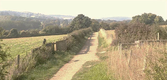
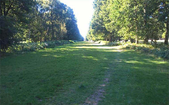
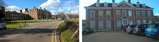
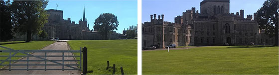
Walk across the front of Ashridge House and go through some white gates and across a sports pitch to a fence. Turn left and look for the golf course and a path which widens out to become the stately Prince’s Ride (left).  A mile away is the distinctive Bridgewater Monument at the end of the broad grass avenue cutting through Ashridge Forest.  No need for a guide or map here.  You cannot get lost.  If you do you really shouldn’t be allowed out.

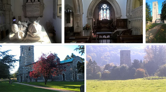
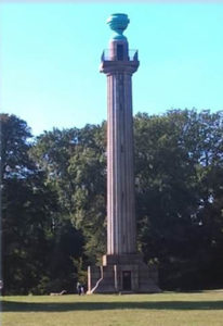
The Grade II listed Doric style granite column was built in 1832 in memory of the 3rd Duke of Bridgewater – known as “the father of inland navigation” as the commissioner of the Bridgewater Canal, often said to be the first true canal in Britain. It is 108 feet tall with 172 steps and from its location near the edge of the escarpment has views over Aldbury and the surrounding countryside. On sunny days you might even be able to see Canary Wharf and The Shard in central London 30 miles away. The cost of climbing it is £2.50p (adults) and £1.50p (children) but check the National Trust website as opening times vary. https://en.wikipedia.org/wiki/Ashridge

The path linking the Bridgewater Monument to Aldbury is one of the steepest ascents/descents in the county and the ridge is one of the five highest spots in Hertfordshire. Head left at the monument and pass in front of the restaurant, toilets, and information/education centre and identify an obvious path ahead which starts to drop steeply down the hill veering right to the quintessential village of Aldbury, a film backdrop with its lopsided buildings, historic inns, village stocks and obligatory duck pond.  If you’re a duck pond enthusiast the Hertfordshire Way is the walk for you. You will pass many. Weston, Letchmore Heath, Northaw, Barkway, Kelshall, Sandon ……..and many other less distinguished patches of water!

The village church of St John the Baptist (below) is of Early English style. It was restored in 1867 and is notable for the Verney Chapel, separated from the nave by a screen of stone and a monument to Sir Robert Whittingham, slain at the Battle of Tewkesbury. There is also a Sheela Na Gig in the north wall of the church, a grotesque figurative carving of a woman with anatomical oddities!!!

As I confessed earlier the lure of The Greyhound pub – greyhoundaldbury.co.uk  – proved too much after a day of being baffled by cereal crops and unimpressed by the River Gade and I called it a day overlooking the pond (below left) with a cheery pint. It is a fitting finale. Certainly more welcoming that a dreary railway station. Though obviously those armed with a rail timetable must eschew the comforts and delights of Aldbury and plod on. The village’s other historic inn The Valiant Trooper (below right) in nearby Trooper Road – valianttrooper.co.uk – is part of a row of 17th century cottages that served as alehouses for many centuries. Its name was changed to The Trooper Alehouse in 1803, reputedly because the Duke of Wellington met his troops there to discuss tactics. It became the Valiant Trooper in 1878

Leave the village with the church on your right and look for an obvious footpath on the same side that skirts behind some farm buildings and leads you to a T-junction on a wide path with Stocks Golf Club ahead.  The roundel here sends you left down the hill.  But it was such a stunning summer morning that I marched resolutely on. Unfortunately a wayward walker standing in the middle of a fairway with an Ordnance Survey map flapping in the light breeze is unlikely to endear you to golfers waving five irons. The correct route is left!!  Follow the path downhill until your reach Station Road and then right to Tring Station. When I first walked the path it offered stunning views ahead (see below). Sadly in August 2020 it was heavily overgrown and the charming vista had disappeared.  Can someone cut the hedges please?

Now it’s on to King’s Langley – or Bovingdon if your legs falter!! – as Leg 7 unfolds in magical fashion.  A long walk, the longest by far, but one to remember.    The best has yet to come.